Mountview Dike Phase 2 & Coal Creek Bin Wall Rehabilitation Project
April 11, 2025
Contruction is set to begin April 14 on the Mountview Dike Phase 2 and Coal Creek Bin Wall Rehabilitation Project.
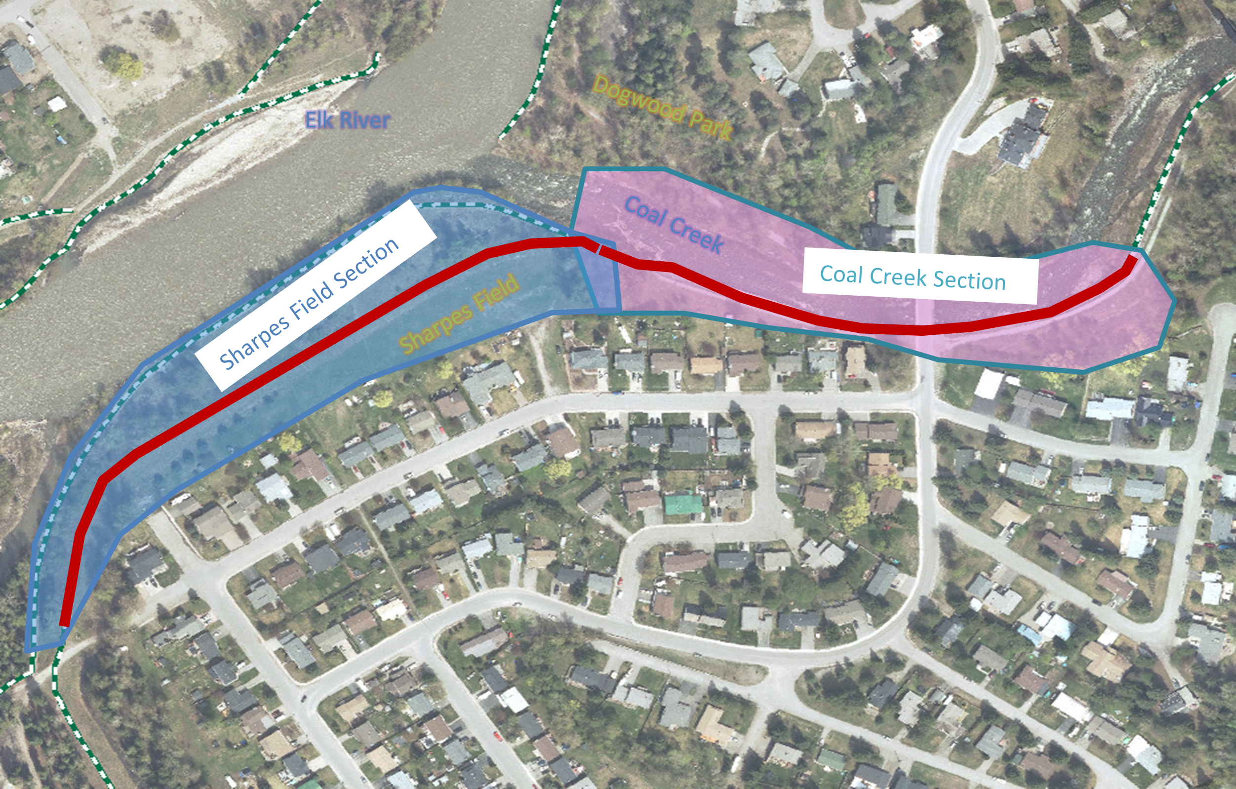
The project will involve disruptions to the TransCanada Trail on top of the dike along Coal Creek and the Elk River, full closure of Sharpes Field, and temporary closures to the south end of the Dogwood Park and associated trails. The work is split into two phases, the Sharpes Field Section and the Coal Creek Section.
Background
The Mountview Dike Phase 2 and Coal Creek Bin Wall Rehabilitation project is the City’s fifth major flood mitigation initiative and is valued at $1.98 million (grant funded).
The Mountview Dike is approximately 2,100 m long and located to the north and west of the Mountview neighbourhood on the left bank of the Elk River. The Coal Creek Bin Wall is approximately 235 m long and is located on the left bank of Coal Creek, just upstream of the confluence of the Elk River and Coal Creek. This rehabilitation project will armour 350m of the dike at the confluence of the Elk River and Coal Creek along Sharpes Field, repair sections of the Coal Creek Bin Wall, and rehabilitate scour protection in the creek.
Phase 1: Sharpe’s Field Section
Expected Duration: April - June
The first phase will impact the Mountview Dike along Sharpe’s Field – from Mt. Minton entrance of James White Park to the start of the Coal Creek Bin Wall. The contractor will be removing trees in the area to armour the waterside of the dike with additional riprap.
TransCanada pathway along the top of the dike and the path along the water’s edge of the park within the Sharpes Field Section will be closed for the duration of repairs.
Phase 2: Coal Creek Section
Expected Duration: July – September
Coal Creek will temporarily be rerouted from its path hugging the bin wall to the opposite side of the creek bed for the duration of the Coal Creek Section work. Several of the bins that make up the bin wall will be repaired, and scour protection will be installed along the toe of the wall.
During this phase, the Coal Creek portion of the TransCanada Trail will be closed from the Cokato Rd access to Sharpes Field. Temporary closures to the south end of Dogwood Park will occur during this time as the contractor will need material storage and access the north shore of Coal Creek. Access to the Dogwood Park Boat Launch will not be affected by this project.
As the work is completed, the contractor intends to re-open areas of the parks and trail network where possible. For both phases, Sharpe's Field will be closed to the public while contractors utilize the area to store materials and heavy equipment. Please respect all marked closures and give crews space to safely do their work.
QUESTIONS?
If you have any questions or feedback about the project, please direct them to operations@fernie.ca
Impacted area residents will receive a written notice outlining the project timeline, trail closures, and potential impacts.


.png)